Driving through Himachal Pradesh offers some of the most beautiful views in India, but traveling here during the peak monsoon season requires extra caution. Intense cloudbursts, sudden landslides, and surging river levels mean that a road open in the morning could easily become completely blocked by afternoon.
If you must travel to the hills this season, here is a practical breakdown of the key routes, active choke points, and vulnerable highway stretches you should avoid or navigate with extreme caution based on current official assessments.
1. The Rockfall Zone: NH-5 (Shimla-Kinnaur Highway)
The National Highway-5 corridor, specifically sections past Rampur through the Nichar subdivision, Jeori, and Nigulsari, is heavily vulnerable to severe rockfalls and flash floods. Recent cloudbursts have sent heavy mud debris washing over the highway.
- Why avoid it: These roads are cut through vertical, unstable rock cliffs. Heavy rain causes “shooting stones”—loose boulders that detach and drop onto the asphalt without warning.
- The Smart Plan: Avoid travelling this corridor during active orange or red rain alerts. If you must pass through, schedule your movement strictly during broad daylight when visibility allows you to spot road obstructions early.
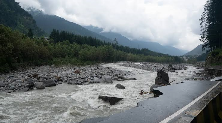
2. The River Vulnerability: NH-3 (Mandi-Pandoh-Kullu Stretch)
The primary highway linking Mandi to the Kullu Valley runs tightly along the Beas River, making it a major risk zone during heavy downpours.
- Why avoid it: This low-lying river corridor is highly prone to structural cave-ins, retaining-wall failures, and water overflow when dam gates open. The section near the Pandoh Dam accumulates thick mud and debris, stalling traffic for hours.
- The Smart Plan: Always verify the highway status with local authorities before leaving Mandi. When the main highway faces issues, look into official traffic diversions via the Kataula-Bajaura hill road, which stays away from the immediate riverbed.
3. High-Altitude Water Vulnerabilities: Lahaul & Spiti Corridors
While Lahaul and Spiti are often viewed as rain-shadow areas, the terrain lacks dense root systems to hold the soil together. This means even moderate rain quickly translates into fast-moving mudslides.
- Why avoid it: Crucial transit routes, including the stretch between the Atal Tunnel North Portal and Sarchu (specifically around Yurnath), frequently face closures due to adverse weather and unstable river crossings. Glacial streams (pagal nallahs) can turn into raging torrents within minutes.
- The Smart Plan: Do not attempt interior valley crossings or high passes immediately following a heavy downpour. Wait for the Border Roads Organisation (BRO) to issue clear passage updates.
Quick-Reference: Strategic Adjustments for Monsoon Transits
| Route Segment | Primary Monsoon Risk | Best Alternative or Timing Adjustment |
| Kalka to Shimla (NH-5) | Landslips near Solan and city-entry bottlenecks (like the Chakkar barrier area). | Depart the plains before 4:00 AM to bypass heavy commercial traffic, or use the Shimla Bypass via Apple Cart Inn to skip central choke points. |
| Interior Chamba Roads | Deep fog, narrow lanes, and lack of sturdy barriers over slick surfaces. | Avoid steep high-altitude links like Jot Pass during rainy spells. Stick to the wider, lower-altitude roads via Banikhet. |
| Foothill Highways | Intermittent waterlogging on link roads. | Stick strictly to broad, well-maintained arterial roads like the Bilaspur-Hamirpur-Kangra Highway rather than trying shortcuts through minor rural roads. |
4 Critical Driving Practices for the Monsoons
- Strictly No Night Driving: Avoid being out on mountain highways past 6:00 PM. Heavy monsoon downpours degrade visibility instantly, and you cannot spot approaching mudflows or fallen boulders on dark roads.
- Yield to Ascending Traffic: Hill driving etiquette is a safety rule—always give the vehicle climbing uphill the right of way. Never attempt blind overtaking on sharp hairpin curves.
- Download Offline Route Maps: Network connectivity can drop out completely in deep valleys. Ensure your route maps are fully cached offline before entering high-altitude districts.
- Track the Daily Bulletins: Conditions change from hour to hour. Check localized updates from district magistrates and state authorities before starting your engine for the day.
Official & Trusted Government Sources
For real-time road clearance, traffic diversions, and weather warnings, rely entirely on official government updates rather than public travel forums:
- Himachal Pradesh State Disaster Management Authority (HPSDMA): Coordinates state emergency operations and posts regular daily utility status bulletins tracking road blockages and structural safety alerts across all 12 districts (
hpsdma.nic.in). - India Meteorological Department (IMD) Meteorological Centre, Shimla: Issues the official color-coded (Yellow/Orange/Red) weather warnings, 3-hour nowcasts, and flash flood risks specifically for Himachal Pradesh (
mausam.imd.gov.in/shimla). - Himachal Pradesh Police Citizen Portal: Provides direct public updates regarding active traffic diversions, localized landslips, and safety guidelines from on-ground law enforcement (
citizenportal.hppolice.gov.in). - District Administration Portals (NIC Himachal): Localized district sites—such as District Kullu (
hpkullu.nic.in) and District Lahaul & Spiti (hplahaulspiti.nic.in)—publish official magistrate orders regarding highway restrictions and pass openings.
Plan Your Journey with Local Experts
If you are planning your Himachal trip from Delhi or Chandigarh and want to navigate the mountains with complete peace of mind, choose Himalayan Tribe for your next adventure. As a homegrown Himachal travel company with years of on-ground experience, these hills are our home. We know exactly how to time your exit from the plains to beat the heavy overnight Volvo convoys, and we understand the changing moods of the mountain terrain inside out. Let a team that’s actually from the hills ensure your journey is meticulously planned, safely routed, and looked after at every single step.